before departure


Pour visualiser le contenu de ce site installez la dernière version du Flash Player en cliquant ici
Si cela est deja fait vérifiez dans les options de votre navigateur si il n'est pas désactivé.


1) MOROCCO RECE TRIP
Back from the recce trip in Morocco. Weather was very bad with heavy rain, mud and snow. neverless the first 4 days have been valided and a second trip will be programed as soon as the weather will be better:
Day 1: Nador-Fez (fast tracks on a large tray),
Day 2: Fez-Marrakech (nice track with a pass 2800m high),
Day 3: Marrakech-Tan Tan (pass of Immichil followed by a sandy track to the biv...ouac)
Day 4 : Tan Tan - Tan Tan, (loop around the bivouac with a lot of sand and first dunes) Some rest for the service teams. there will be another loop in Mauritania
Presentation of the rally at the DAF museum in Eindhoven (Holland) on feb 3
Presentation of the rally at the MCM Motorcycle Show at Excel exhibition centre London, from 3rd to 6th of Feb on the Desert Rose Racing stand
Euro4x4parts.com new partner for Heroes Legend 2011. Special offers for the participants
See you in October 2011 for the 6th edition with many novelties (route, navigation and categories).

2) THE PINK LAKE ......
THE LEGEND !
Finally, the reward for all the efforts and a dream comes true when the competitors arrive at the beach which leads to the ‘Lac Rose’. A big moment to cherish and to taste the victory, passing the finishing line with the pride to be able to say, " I dreamed about it and I’m there, I did it". The competitors of this 5th edition of the Heroes Legend rally do not dream about it anymore, they are now part of the legend of the Paris-Dakar.
After the tour of the pink lake and the last kilometers on the beach, the competitors have passed the finish line ! a lot of happiness and emotions.
The winners of the 5th édition of the Heroes Legend rally :
1st motorbike Open, Chris Barwick, Uk
1st motorbike Classic, Claudio Zago, Italy
1st car Open, Csanyi/Csanyi, Hungary
1st car Classic 1, Gabrielle/Py, France
1st car Classic 2, Martegoute/Dupont, France
Thanks to all the competitors for the show during those 2 weeks of race and mark already your agenda for october 2011 for new adventures on the Heroes Legend rally !
HL STAGE 9: SAND, SAND AND ONCE MORE SAND
Today for 420 kilometres in Eastern direction the fscent was followed where the longest train drives in the world concerning. On such a 40 a 50 kilometres for end Southern it was branched off direction the city Atar, where it bivouac lay near. There no connection route needed be driven, therefore the participants could itself ` s morning asked seven hours directly pay on the spicy piste. It was not as warmly predicted as and in spite of that it was very very sandy, the first drivers came in already for half two ` s afternoon. The rest of the field was for obscurity at home.Marc, of Daddycool2dakar-rijders, did not succeed it to obtain bivouac on own strength it. He has fallen in the last kilometres, flat for bivouac and with that its shoulder has this way hurt that he can drive no longer further. The misfortune of, is it luck for another one. Harold, the other Daddycool, have blown up its engine during 8th the stage and the end of the tale for him seemed. Now Harold on the driving force behind Marc can drive nevertheless further.In Morocco and in western Sahara it was already green, but Mauritania beats everything. Where normal only sand is, now complete ponds with vegetation be. Tomorrow the king stage with cols, oases and much sand is.
HL STAGE 8: Good-bye Morocco, hello Mauritania
Today a half rest day was, the participants had, as it happens, no drive special. The route amounted to kilometres however still 375, with halfway the border crossing to Mauritania. Henk Knuiman are glad that he can continue drive with its new navigator, manful obscurities, by. They have the hope give up to get after the buggy of manful still mobile, he came stand during the first day already quietly. It is this year heavier than ever endorse also Thomas the Bois and Evert crown. Where it was in 2008, still heavy by extreme heat, it is heavily now terrible by the chosen route. What is notable, is that it is by fallen rain terribly greenness. This must be a relief for the nomads, there is enough food for their animals.Many participants used of the quiet day to take the vehicles well under hands. The arriving days go heavy become. The route runs further country-inward and that means that the airco from go. Cold roars that blows of the Atlantic ocean the participants no longer are able reach, as a result of which the temperature of a degree or 23 will increase up the 40 degrees! The level of some engine drivers lies not very high and that go heavy getting.
HL stage 7: LONG AND FAST
The 574 kilometres long stage of Boujdour to Porto Rico were still used for last in the Dakar of 2005. Dakarrijders experience Thomas directly the Bois and Evert crown recognized the route. The day had unfortunately a person who drops out. Giovanni Uliana fell with they traditional tenere on 10km for end quietly. Instead of waiting for the bezemwagen, he chose there for to let drag itself by a car. Then the car speed diminished in sand arrived the towrope in the voorwiel of the engine. The driver with start number 14 came at fall and with the helicopter for certainty has been transmitted to a hospital in Dacla. Tomorrow he returns to Italy.The route with a special of wide 500 kilometres was there rapidly and flat with a couple violent hobbels in. The first participants came in already around two hours it bivouac. These lay in a beautiful lagoon where a cold bleak wind blew doorheen.
HL TRAINING PERIOD 6: LONG DAY
Van Tan Tan to Boujdour. After 400 kilometres connection route the participants of start in the first special could. By means of a number of dunes and a number of pieces range, the special finished on the range of Laayoune. Team 200 came of the found oneself side at the checkpoint at the end of the special. By means of an impulse the car wanted the team turn, but the links bit in sand as a result of which the car of Egbert Wingens and Carlo Reijs on reached its they side standstill.The second special started even booty Layoune. Participants could go up to the quarter concerning three of start, but at seven o'clock ` s evenings not yet the everyone checkpoint have passed. To make with many stones and had they got the drivers which could go, however, of start deep gaps cross out. Just for 23:30 came the bezemwagen it bivouac drive in, what meant that all participants of special finished are.It not yet succeeds with the car of team Africarrera. The Porsche drive of bivouac to bivouac and do not go of start in special. The Renault 20 on the other hand go super and without problems have arrived today. In bivouac a sickness dominates. Many menses are sick, among which Yvonne Vooren of the Desert Daltons. Also Marc of pine tree, of the Daddy feel themselves sick, weakly and sick.It is considerably fought in the klassement. The participants get sentence points if them waypoint missing. They get more sentence points if they speed too, then if they drive too gently. All they participate fanatically.The caravan draws increasingly further to Mauritania. Tomorrow a large step is made with a long day. The special is wide 500 kilometres long!
Saturday, October 23
Stage 6: Tan tan - Boujdour: 681 km
A very long stage awaited our competitors today. A long sandy track on the beach was favourable with navigation. The participants really appreciated this moment. However, to find its road between the dunes does not have a being of any rest!
The second special one was of a surprising beauty, the tracks were strewn with volcanic craters and gigantic dunes where the good passage had to be found… a landscape to cut the breath! more especially as they bring the participants to the bivouac of Boujdour, positioned on a sand beach white where the sun lies down on the ocean…
Only small shelf of the day: the n° 200 which in a dash of zeal wanted to ensure the spectacle on arrival of the first special one whereas it had deflated its tires to pass sand… Result: a beautiful barrel but reassure there was itself more for fear of evil! however cheer the spectacle was assured! Our cameramen were there…
Friday, October 22
Stage 5: Tan tan - Tan Tan: 203 km
This short stage around the fort of Tafnidilt was composed of two loops. Two sand valleys await our competitors. After having succeeded in thwarting the traps of these sand dunes enclosed in a wadi, the competitors moved on the second loop towards the fort of Ayoun of Draa. The shovels and the plates of désensablage were of exit and the mutual aid between participants once more functioned well.
This beautiful loop brought back them without encumbers to the bivouac for one evening of rest deserved well. Our cameramen had prepared first ahead a small meeting cinema: the first images of the last stages were appreciated of all!
Thursday, October 21
Desert with the Atlantic Ocean
Stage 4: Foum Zguid - Tan Tan: 582.99 km
This 4th stage makes us pass from is in west to arrive on the Atlantic coast of Morocco. Two long special awaited our participants. If the second unfortunately had to be cancelled because of military operations on the sector, the first took place well. It is about a layout carried out for Paris-Dakar of 1996.
To pass on the traces of largest of mythical Dakar was a real adventure for all! To connect parallel wadis and tracks put to the test the navigators…
The participants particularly appreciated the passage of the chotts at high speed.
A long connection finally led us at the height of Tafnidilt. A loan place of history… Our bivouac is located in the wadi enclosed between the old one extremely of Tafnidilt and the hotel of the same name which preserved an identical architecture. Definitely last and present intersect since the morning…
Side competitors porch 911 had still engine trouble and repairs before its arrival with the bivouac…
Step 3: Merzouga - Foum Zguid: 495 km One Step waited long enough competitors today with a great classic "Dakar", Erg Chegaga followed Lac Iriki and ending at Foum Zguid. Little difficulty with the first part of the wheel tracks with very few sandy stretches but navigation is a little difficult sometimes ... for some of the highlights of the day: No. 151 - Renault 20 - produced a superb performance in the first stage without any help or hindrance. The second part of this special will leave memories to many. A portion of the dune quad 8km No. 30 had mechanical problems: broken transmission. A long night in perspective in order to repair before the start of tomorrow ... He is 19h and many competitors are still on track towards the camp ... ... the brush truck is already at work to bring everyone back. D others arrived too late to start the second half of the stage, took the road to reach the camp. On arrival a bivouac at the foot of the exceptional "Tagine" and the oasis of Foum Zguid ... The sun sets over the beautiful mountains without all the crews are still arriving ... Latecomers arrive probably late in the night ... The winner of this third step is: In the motorcycle category open: No. 16 Barwick KTM classic Category: No. 14 Yamaha Uliana By Car class open: No. 216 Szebenyi / Szállás on classic Mercedes Category: Quemin No. 222 / Borde Toyota Winner General: In the motorcycle category open: No. 16 Barwick KTM classic Category: No. 15 Yamaha Zago By car open category: Csanyi No. 211 / Category Csanyi Toyota Classic: No. 235 Arendt / Schandeler on Toyota
Tuesday, October 19
Step 2: Mengoub - Merzouga: 353 Km's it! The long-awaited first dunes are here! The race is accelerating on sandy tracks through the wadis. Porsche has gardened in the first few miles and there are many who have yet to learn side navigation ... spectacular dunes of Merzouga are worth! The most courageous and experienced have had a taste of what will be the 2010 rally. Tonight: bivouac in Merzouga: an appointment not to be missed! Tayeb welcomes us into his establishment at the foot of the dunes, a great place that served as decor for many films. The winner of this second step is: In the motorcycle category open: No. 31 Verzijl on honda classic Category: No. 14 Yamaha Uliana By Car class open: No. 211 Csanyi / Csanyi Toyota Classic Category: 227 Moutou / Sexy Toyota Winner of General: In the motorcycle category open: No. 31 Verzijl on honda classic Category: No. 15 Zago Yamaha In open class car: No. 211 Csanyi / Csanyi Toyota Classic Category: 235 Arendt / Schandeler Toyota
Monday, October 18
Go! Step 1: Nador - Mengoub: 570.83 Km arrived in Nador at 5:00 (local time: - 2h) competitors have joined the first stage after a quick breakfast. These first 570 km, gave participants a taste of the upcoming special: navigation and reading the road book will be the watchwords of this rally. Two special 67.26 km and 114.35 km were chained between forest tracks, fast tracks and stony passes, along the Algerian border. Some vehicles have experienced any mechanical problems but only the buggy No. 218 can not match the start line of the 2nd day. Making contact with the navigation and use of GPS has proven difficult for some ... but all ultimately joined the camp. As for results, the winner of this first step is: By bike: Barwick No. 16 on a KTM. Drive open category: Csanyi No. 211 / Toyota Csanyi. Classical category: 227 Moutou / Sexy Toyota
Sunday, October 17
Montauban in Almeria The Sunday took place as of Saturday afternoon: free transit to Almeria. All participants joined the port for the briefing of competitors 19.00. The Porsche 911, despite its setbacks in the prologue has also embarked for Morocco. After the formalities of customs and police, competitors enjoyed a well deserved night.
Saturday, October 16
WARM UP 8:00, all by leaving the park closes for Birac or place the prologue. The morning fog dissipates and finally start competing for two reconnaissance laps of the circuit traces by Pascal Larroque that Montalbanais familiar. A beautiful 4km circuit that competitors will ride 3 times. Already the first disappointment with the quad that makes No. 28 a barrel. The injured driver is carrying al hospital de Montauban> Bras case he is forced abandonment al. The Porsche 911 No. 76 s stopped in the second round of problems with gasoline. Pump case. He repairs. The Range of Toulouse Dominique Gabrielle also has fuel problems> After this prologue the competitors took to the road and be at the port of Almeria - Spain on Sunday evening to take the boat to Morocco.
Friday, October 15
MONTAUBAN ........ HAT! All participants had an appointment to Montauban for the scrutineering of the vehicles Albasud. Competitors are going one by one the different booths, passports, stickers, medical, road book ........ At 17h everyone left the area Albasud in convoy towards the city of Fountain Square or the Parc Ferme was installed. After a presentation of each competitor on the podium were the competitors waited for the briefing and dinner al Old College in the presence of the Mayor of Montauban. The Montalbanais have come many a warm welcome to Heroes Legend Rally.


|
Les infos
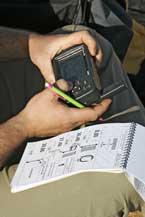
In order to be able to travel from point A to point B, first of all it is essential to know what direction you should move in and for how long or for how many metres, but prior to this one has to accurately determine:
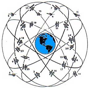
SCALE BEARING Global Positioning System
Using a GPS doesn’t mean you don’t need to think or to check an itinerary using other media, such as maps and the road book, or to question the information provided!
Historie : The development of this navigation equipment was directly linked to space exploration and the competition in this field.
A – the number of waypoints... C - Set Up or Initialisation...
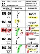
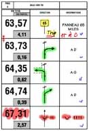
Road Book... A road book is a collection of notes that indicates changes in direction, hazards, bearings to follow and WPs… These notes are made by the organiser during his reconnaissance of the course and they must be followed to the letter by competitors. The road book for the following day is issued by the organiser at the overnight camp. Page de Road Book
Markers, partial mileage calculations and part of the layout are done by computer: mistakes in calculating partial distances are very rare; it is not compulsory to check all the partial distances. An “opening car”, which is 2 or 3 days ahead of the ride, checks the road book and carries out any last-minute alterations which are passed on Trip... The box... The mileage probe...
HOW TO FIN SPONSORS FOR THE RALLY HEROES LEGEND 2010 ? There is no secret recipe but some advices can always help. Before setting off in an active search for sponsors, ►What is my project ?
►What is my budget ?
►Who are my potential partners/sponsors ?
►My pitch ? How to sell it ? When you have answered to those questions, you have to prepare a personalised dossier to present your project. This presentation must be clear, concise, persuasive and imaginative; it must make them dream of the rally but also convince them of your personal qualities. ☼You need to highlight your special features, your motivation: ☼Present your arguments to justify sponsorship:
☼To build a relationship with their suppliers/customers. • Propose them to follow you during the event thanks to the category Bivouac Bivouac, they can enjoy nice roads and meet you at the bivouac every night. • To enable the partner company to enjoy tax relief. Depending on the country, sponsorship offers tax breaks. Consider putting forward a small sales pitch to demonstrate these tax breaks according to the legislation in your country. ☼Highlight the benefits of financial support or support in materiel : ☼Finally, very important to keep good relations with your sponsor … |
Pour visualiser le contenu de ce site installez la dernière version du Flash Player en cliquant ici
Si cela est deja fait vérifiez dans les options de votre navigateur si il n'est pas désactivé.